
Champaign County Neighbor Sources
A block lookup works best when “neighbor” has a clear meaning. It may mean a parcel sharing a boundary, a home on the same block face, a lot in the same subdivision, or an address inside the same registered organization. State the chosen scope before collecting records. The sources below answer different parts of that question.
| Source | What It Shows About a Block | Access |
|---|---|---|
| CCGISC public maps | Parcel geometry, PIN context, intersections, and map layers | Online map |
| Tax and assessment records | Recorded owner and mailing information tied to a parcel | County lookup |
| Registered organization layer | Group boundary, type, council district, and police district | Public ArcGIS data |
| Neighborhood or HOA registry | Organization name, boundary lead, and public contact | City list or request |
| Plats and historical maps | Subdivision, lot, street, and physical change context | GIS, recorder, library, or archive |
Owner and occupant are not synonyms. A tax mailing address may be elsewhere, and renters or other household members may not appear in parcel data. A group polygon establishes only that an address falls within a registered shape. It does not establish membership or permission to contact an individual.
Map Champaign County Adjacent Parcels
The county GIS method begins with one verified address and walks only to the lots that fit the stated scope. CCGISC supplies map and tax-atlas context, but its general index is not a legal survey. For a disputed line, rely on the recorded plat, deed description, survey, or custodian rather than the screen boundary.
- Normalize the house number, direction, street suffix, municipality, USPS place, ZIP, and parcel identification number.
- Locate the parcel in the CCGISC map, then use identify and adjacency tools to inspect bordering parcels or the chosen intersection.
- Record parcel owners, mailing addresses, current occupants, and organization boundaries in separate fields. Do not infer one from another.
- Check a subdivision plat, tax atlas, historic aerial, permit, or title abstract if a lot shape or street edge has changed.
- Use the registered organization’s public contact when the goal is a local introduction or question.
A whole-road search has a different scope. The Champaign County street directory follows the full named street through address-keyed records, while this method stops at the immediate block or selected radius.
Champaign County Neighborhood Polygons
Champaign’s Registered Neighborhood Organizations layer is a queryable polygon source. Its fields include Group_ID, Group_Name, Group_Type, four boundary descriptions, Plan_Area, Council_District, Police_District, Registration_Date, and region_name. The ArcGIS service supports queries, pagination, and GeoJSON-style output. That makes it useful for testing whether an address falls inside a public organization boundary without collecting member names.
The official registered organization GIS layer exposes the public map service and its documented fields:
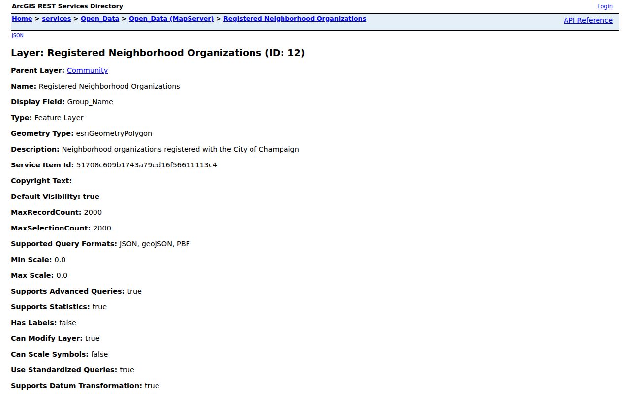
The captured service page supports reproducible boundary research. Save the layer URL, query, retrieval date, and coordinate assumptions. A polygon can be approximate or administrative, so a boundary dispute still belongs with the city or organization.
Note: A neighborhood polygon gives civic context for Champaign County neighbors; it is not a surveyed parcel line or a household roster.
Contact Champaign County Neighborhood Groups
Champaign registers voluntary groups whose areas may include homes, businesses, schools, and churches. Listed associations include 500–800 W Washington, Beardsley Park, BPM², Carver Park, Clark Park, Garden Park & Edgebrook, Garwood, Holiday Park, Martin Luther King Subdivision, Ridgewood South, and United Garden Hills. Neighborhood Services handles registration at 217-403-7070.
| Organization route | Useful public fact | What it does not prove |
|---|---|---|
| Champaign association | Registered boundary and public contact | Occupancy or group membership |
| Champaign HOA | Subdivision or organization lead | That every parcel belongs or dues are current |
| Neighborhood Watch | Public safety group and agency contact | Authority to investigate a person |
| Urbana neighborhood map | Urbana group label and map context | A Champaign registry boundary |
Urbana uses its own neighborhood labels, including HEUNA, Middle Urbana, SUNA, WUNA, LNAC, Downtown Neighborhood Association, and AmVets II. Do not copy an Urbana label onto a Champaign polygon. County and city lines matter because the keeper of an association, annexation, or local-improvement record changes with jurisdiction.
Champaign County HOA and Watch Context
Champaign’s HOA list includes groups such as Ashland Park, Cobblefield Point, Copper Ridge, Devonshire areas, Glenshire II, Ironwood, Parkland Ridge, Ponds of Windsor, Sawgrass, Turnberry Ridge, West Ridge, and Wills Trace. Registration is associated with nonprofit registration through the Illinois Secretary of State. A name on that list is an organization lead, not proof that a given home is a member or that the listed contact is a current neighbor.
The city also lists Watch groups in Edgebrook, Jordan Drive, Mittendorf, North Willis, South Ridgeway, South Willis, Victor, West Haven, and other areas. Its stated threshold is at least 10 homes, participation by half the households, and two meetings per year with police or Neighborhood Services. The Champaign County Sheriff says residents may join or form a watch around a block or area, while stressing that members are not vigilantes. The county community route is 217-384-1204.
For routine contact, use the organization’s published channel. For an urgent danger, call 911. Champaign Police nonemergency is 217-333-8911. A watch group supports communication and prevention; it does not turn a parcel search into permission to observe or confront anyone.
Protect Champaign County Member Rosters
The city registration form separates public contact data from more sensitive submission fields. It asks for an organization name, year formed, north, south, east, and west boundaries, two primary contacts, added contacts, a member roster, public contact details, social links, issues, and Watch status. That design is a warning to request only what the civic question needs.
For an association boundary, ask for the group name, type, four boundary fields, registration date, and public contact. Do not request or republish the roster merely because it appears on an administrative form. Critical-issue text and personal contact fields may also contain sensitive facts. Under the Illinois Freedom of Information Act, a city may redact private information or an unwarranted invasion of personal privacy.
Online lists are only one channel. Neighborhood Services can clarify a Champaign registration by phone. CCGISC can answer map questions at 217-819-3555 or ccgisc@co.champaign.il.us. Municipal staff, the city clerk, and local archives can supply boundary, annexation, or local-improvement records in person or by a narrow written request.
Official Records for Champaign County Neighbors
Commercial neighbor tools often merge address, phone, parcel, and other brokered data with unclear dates. Official sources are narrower. Their limits are useful because each fact has a custodian, date, and stated meaning. Neither category proves who is inside a home now, but public records make it easier to keep ownership, civic boundaries, and historical context distinct.
| Question | Official route | Why it is safer |
|---|---|---|
| Which lots border this one? | CCGISC map and recorded plat | Defined geometry and a traceable keeper |
| Which group covers the address? | Municipal registry and GIS polygon | Public boundary without a member list |
| How can I reach the group? | Published organization contact | A neutral, opt-in communication route |
| Why did the block change? | Plats, aerials, permits, and local-improvement records | Dated physical and civic context |
Keep a short log with the address form used, PIN, chosen definition of nearby, source URL, retrieval date, and caveat. Do not combine current voter, jail, registry, and parcel details into a household profile. More data does not make a claim more accurate.
Privacy for Champaign County Neighbors
A public directory or parcel record may show that a name was linked to an address at one time. It does not authorize entry, repeated contact, surveillance, or publication of a private home location. Utility, delivery, and private association rosters are not general public neighbor directories. Protected, sealed, juvenile, and victim-related data must remain closed.
Lawful use. Research Champaign County neighbors for civic context, property history, a public group contact, or personal safety. Never use records to monitor, intimidate, harass, or expose someone.
The Illinois Attorney General’s Address Confidentiality Program gives eligible survivors a substitute address, although it cannot ensure property-record confidentiality. If a person may be protected, do not seek a workaround. Use a neutral intermediary, library, historical society, or organization contact to forward a legitimate reconnecting message.
When a map or registry says nothing, state the gap. The parcel may sit outside a registered polygon, a boundary may have changed, or the data may not yet be updated. Ask the custodian for the current boundary fields rather than guessing from a nearby group name.